rashelju
Bangladesh

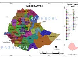
We need a series of maps (minimum 5 side by side) that show Ethiopia's redrawing of it's borders by it's provinces from 1935, attached below(1st map) then by the current Regions, Zones, and Districts (2nd map) then the intended map the TPLF party wanted, attached below (3rd map). These 3 maps should of the whole Ethiopia.
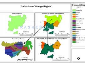
2 additional zoomed in maps should show the the annexation of Amhara regions towards the Tigray region as well as the Gurage region being divided into multiple districts.
Regions should be colored with border lines being distinct. All maps should be consistent in format and illustration, detail, and must include a legend.
This will require an understanding of each level of subdivision for the nation of Ethiopia. The following link provides information that will ensure an understanding:
https://en.wikipedia.org/wiki/Subdivisions_of_Ethiopia
Below is a series of links that show the specific annexations of regions we' like focused on for the maps. Important items to highlight visually is the reduction and division of the Gurage Region entirely after 1991 as well as the Tigray regions annexation of Amhara regions (see pictures).
https://upload.wikimedia.org/wikipedia/commons/thumb/8/80/Map_of_zones_of_Ethiopia.svg/800px-Map_of_zones_of_Ethiopia.svg.png
“Kazi is awesome; the quality of his work is amazing. ”
![]() water4humans, United States.
water4humans, United States.


Publica tu concurso Fácil y rápido

Consigue toneladas de propuestas De todo el mundo

Elige la mejor propuesta ¡Descarga fácilmente los archivos!